The activity in Campground Loop A of the Sand Flats Recreation Area has a weekend hustle and bustle feel to it. Both of us kept checking our phones, it feels like it’s Saturday, isn’t it Saturday? What time are the Badgers and Cougars on ? Alas, it’s only Friday. A lazy morning quickly turns into a lazy afternoon. Eventually, CW decides to tackle the Slick Rock bike trail. We headed that way on bikes, but only one of us is entering the fabled grounds.
We’re happy to report, there was no need to find the local hospital. But we both found it comical and practical that Grand County offers that nugget of info along with the weather forecast at the entry to the trail.
 CW chased a couple of kids for several miles, finally passing them on a long, steep hill, while proudly proclaiming, “see, there’s at least one thing as I can do better than you guys.” The kids constantly smoked him on anything but the big climbs.
 It’s worth noting, the Old Man was gassed by the time he got to the parking lot. He may have smoked those kids on that big hill, but It’s unlikely they are huffing and puffing in the parking lot.
We headed back to camp to see what Friday afternoon would bring us on the 4x4 trails visible from camp. We climbed a slick rock mesa to get a view of multiple trails.

 Does vehicle look safe? We both guessed that ice chest on the back was full of beer.
 The tour services all stopped at the same place, acted like they couldn’t climb the trail, then gunned it up and over to the delight of the passengers. Amy was on that tour at Rod’s Cadillac Ranch way back in the ‘80’s. Those jokes never get old. Nonetheless, this is a bigger scale.
 This guy in the red Jeep Cherokee had second thoughts after the first hill and tried to reverse course.
 One of two things happened next . . . either the driver convinced the passenger they could make it through the entire trail, or the other way around. Either way, they reversed course again and were later seen climbing a hill in the distance.
 Truth be told, we never saw any vehicle in trouble or danger. You would think at least one fool would try his hand at this trail and get stuck, thereby causing a massive traffic jam on top of one of the fins. It was all very well done.
We’re happy to report, there was no need to find the local hospital. But we both found it comical and practical that Grand County offers that nugget of info along with the weather forecast at the entry to the trail.
CW chased a couple of kids for several miles, finally passing them on a long, steep hill, while proudly proclaiming, “see, there’s at least one thing as I can do better than you guys.” The kids constantly smoked him on anything but the big climbs.It’s worth noting, the Old Man was gassed by the time he got to the parking lot. He may have smoked those kids on that big hill, but It’s unlikely they are huffing and puffing in the parking lot.We headed back to camp to see what Friday afternoon would bring us on the 4x4 trails visible from camp. We climbed a slick rock mesa to get a view of multiple trails.
Does vehicle look safe? We both guessed that ice chest on the back was full of beer.The tour services all stopped at the same place, acted like they couldn’t climb the trail, then gunned it up and over to the delight of the passengers. Amy was on that tour at Rod’s Cadillac Ranch way back in the ‘80’s. Those jokes never get old. Nonetheless, this is a bigger scale.This guy in the red Jeep Cherokee had second thoughts after the first hill and tried to reverse course.One of two things happened next . . . either the driver convinced the passenger they could make it through the entire trail, or the other way around. Either way, they reversed course again and were later seen climbing a hill in the distance.Truth be told, we never saw any vehicle in trouble or danger. You would think at least one fool would try his hand at this trail and get stuck, thereby causing a massive traffic jam on top of one of the fins. It was all very well done.


 It was an adventure, picking our way between the slabs, not sure where we were headed, and never knowing what lie around the next corner or through the next crack.

 Wilson had some trouble here, his waist may be 32 inches these days, but that belly will not squeeze through a six inch crack.
 Around a few more fins of sandstone, he found a crack that was more his size.
 Remembering your route was critical . . . back up that, across the draw, third crack on the left, make a u-turn around the slab, take the slot on the far right, then down the rocks etc etc etc. . . In this view, our only path out was the crack with the large shadow from top to bottom in the right-middle of the photo.
 The entire Fiery Furnace is just a few square miles, but you can get trapped quickly with the desert in view, but tantalizingly out of reach.
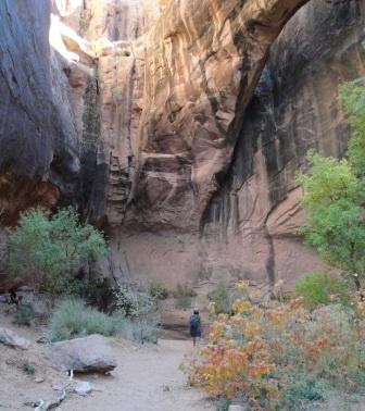
 After negotiating our way back and having some time to spare before sunset, we took a side route and were rewarded with an enormous arch, completely hidden from view until you stepped under it.
 In this land of adventure and extremes, today, we felt like the cool kids. Going at it alone, no maps, having only yourselves to rely on. When and how we returned was solely in our hands.

 Finally a text. “I am ok, just slow going.” With the scent of clean clothes in the FJ, Amy proceeds back up the road to save the poor guy from the several mile road slog back to the meeting point. What a surprise. The trail was longer than expected, or more technical, or whatever. A happy marriage does not include Amy on that agenda, and this time, we made the right choice. The bike warrior returned tired, but unscathed.
 The weapons to attack the desert trails come in all shapes and sizes. The kids around the corner have 3 mini ATV’s, the compound across the street has at least 10 mountain bikes, and the guys next to us have several bikes, and three 4x4 vehicles. Loop A of the Sand Flats Recreation Areas only has 15 spots, but it looks like Grand Central Station around here. SFRA is a unique place, located only about 3 miles from downtown Moab, it’s a place where muscle power and horse power come to play.
 It’s worth noting . . . within the apparent chaos of the miles of slick rock domes and hundreds of vehicles, this place is very well organized. There are several defined trails, and people stick to them.
 That is the scene directly above our campsite. We have resisted the temptation to take the FJ on the “Baby Lion’s Back” trail for one very pointed reason. How would we look if we rolled our FJ off the trail and landed on our trailer? We have no desire to be nominated for a Darwin Award.


 This represents half of the people we see today on the Colorado Overlook road. The remaining parties were a lady driving a Land Rover, and a very serious duo in a jeep with a snorkel, 20 extra gallons of gas and driving gloves. We accept defeat and park about a mile from the rim. Do we really need to go down (and back up) this chunk of road?
 The wiser course of action seemed to be parking and allowing the scenery and canyon to slowly unfold while we walked. Maybe Old Joseph has taught us a thing or two. The Canyonlands do reward intelligent choices. It also offers incredible views for those that make the journey.
 We returned to FJ and made our way back to the Visitor’s Center, CW went in to give a trip report for bikes on the Overlook Road and to get a preview of Elephant Hill, the famous 4x4 trek in the Canyonlands. After letting the nice lady know that the sand was manageable, he inquired about Elephant Hill, he asked for a comparison to the last mile of the Overlook Road (the part we didn’t drive), she responded that the easy parts Elephant Hill were tougher than that stretch. Okay, sounds good, this duo will not be tackling that road.
 We both wondered, should father be watching son or the other way around if they came across that sign? We’re not sure where they went that afternoon, but I do know we returned to camp for another warm night and sunset to match.
 Amy chose to park at Loop B in the campground, thereby giving us an extra mile of fun stuff before reaching the trailhead. We immediately got lost, in most cases, cairns are eye candy, in Canyonlands, they are essential, but tough to find on the steep slickrock slopes. This isn’t “Crack in the Wall” or “Hole in the Rock”, but it was our passage from one mesa to the next.
 Where we quickly got lost again, how do we get down? We can see Big Spring Canyon (our intended trail), but right now this mesa has us stumped. Wilson confirms with GPS, yep, we’re on a mesa, and the trail is over there somewhere. Meanwhile, Amy scrambles from side to side, eventually finding us safe passage to the valley floor.
  After consulting the map, we’ve decided on ascending Big Spring Canyon, crossing over the pass, then descending Squaw Canyon to Loop A of the campground. Careful math tells us we’ll be just shy of 8 miles, and our legs are feeling good. The sweat on our brows told us it was smoking hot, much warmer than Page, to the tune of 90 degrees. We stopped for lunch at an actual spring, enjoyed the shade and rested up to tackle the pass into the adjacent canyon. This was our last chance to take the easier way out, just retracing our steps. With every step forward, it would be quicker to return via the other canyon. Big Spring Canyon ended in a large basin with a huge mesa looming above us.
 How do we exit to the other canyon without ropes and skills to use them? Part of us said, “It’s a National Park, the trail will be marked”, the other part said, “Ha ha suckers, we got you again”, did you think this was Mt. Rainier?”. Once again, we followed the widely spaced cairns. At this point, Amy considered turning back, but that would require going down all the crap she just came up.
 This thought would come up again a few more times. In this pic, we’ve reached the pass between canyons, but have zero idea how to get down into the new canyon. That little object about to enter the shadow at the bottom is Amy.
 Wilson climbs higher and eventually spots cairns marking a path that seemed counterintuitive, but following rocks stacked in a nice pile by an unknown stranger was a better idea than either of us had at the time. And we really didn’t want to go back down what we just came up. The descent in Squaw Canyon was kind of like a slip and slide with no water and plenty of grip for our shorts.
 Throw in a 3 mile sandy slog on the canyon floor, along with some bonus slick rock mesas in the final 800 yards, we were bushed and tired of drinking very warm water. Time to get back to camp and enjoy some cold beers from the comfort of a Cabella Chair. . . .Oh wait, this campground doesn’t look like the one we parked at. Dam . . . A bonus half mile to the car awaits, after scouring Loop A for the path (up and over another mesa) to Loop B. We arrived back to the Rebel just in time to enjoy an outdoor shower and for false hope from Pullman when we turned on the tv to find the mighty Cougs only down by 3 at halftime.